Crop Monitor for Early Warning
Report Information
No. 117: Published July 2nd, 2026
Conditions as of June 28th
For access to all reports, please visit the Archive.
Please visit the Referencing Guidelines page for information on how to cite the Crop Monitor reports and products.
Overview
In East Africa, expanding rainfall deficits are impacting ongoing cropping activities in most areas, and prolonged dry and hot conditions are expected to result in poor yield outcomes in Somalia.
In West Africa, agro-climatic conditions remain generally favourable for main season cereals, though conflict continues to negatively impact agricultural activities in affected areas.
In the Middle East & North Africa, prospects remain favourable as the wheat season nears completion, except in western Libya.
In Southern Africa, harvesting of main season cereals is now complete in all regions with generally favourable end of season outcomes despite unevenly distributed rainfall.
In Central & South Asia, agro-climatic conditions remain favourable for winter wheat harvesting and spring wheat development.
In Southeast Asia, conditions are generally favourable, except in Thailand, which is experiencing drought, and in Thailand and southern Viet Nam where higher input costs are negatively impacting wet-season planting.
In Central America & the Caribbean, there is ongoing concern for the start of the Primera season due to ongoing erratic rains and high temperatures that are negatively impacting planting and irrigation capacity.
Crop Conditions at a Glance
Crop condition map synthesizing information for all Crop Monitor for Early Warning crops as of June 28th. Crop conditions over the main growing areas are based on a combination of inputs including remotely sensed data, ground observations, field reports, national, and regional experts. Regions that are in other than favourable conditions are labeled on the map with a symbol representing the crop(s) affected.
EAST AFRICA: Expanding rainfall deficits are impacting both Belg season harvesting and main/Meher season crops in most areas. Dry and hot conditions are expected to continue through September, followed by a potential shift to wetter than normal conditions from October (See Regional Outlook Pg. 8).
WEST AFRICA: Planting and development of main season cereals is underway in all regions, and agro-climatic conditions remain generally favourable with adequate rains received.
MIDDLE EAST & NORTH AFRICA: Wheat harvesting is nearing completion with mostly favourable yield outcomes expected, except in western Libya. Rice cropping remains favourable in Egypt, Iraq, and Iran.
SOUTHERN AFRICA: Harvesting for the 2025/26 main season is now complete with generally favourable end of season outcomes, except in western Angola, southern Malawi, northeast and southern Mozambique, and southern Madagascar. Winter wheat planting continues under favourable conditions.
CENTRAL & SOUTH ASIA: Overall conditions remain favourable for winter wheat harvesting and spring wheat development. In Afghanistan, 2025/26 wheat production is expected to be near normal despite below-average cumulative precipitation and snowpack levels this season.
SOUTHEAST ASIA: In the south, harvesting of wet-season maize and rice is nearing completion under favourable conditions, and planting of dry-season rice is progressing despite some delays. In the north, planting of wet-season maize and rice is underway with drought concerns in Thailand, and higher input costs are negatively impacting planting in Thailand and southern Viet Nam.
CENTRAL AMERICA & CARIBBEAN: Planting for the Primera season continues with concern in all regions due to erratic rains and high temperatures, which are expected to continue through September (See Regional Outlook Pg. 19). Overall irrigation capacity is diminishing. In Cuba, additional sanctions imposed in May compounded the fuel crisis with significant impacts on the agricultural sector.
Global Climate Outlook: Two-week forecast of areas of above or below-average precipitation
The two-week forecast (Figure 1) shows a chance of above-average precipitation over the western US, northwestern Mexico, northern French Guiana, Central West Brazil, northeastern Bolivia, northern Chile, central Spain, southern Italy, southern Albania, North Macedonia, Greece, southern Bulgaria, northern Norway, northern Sweden, northern Finland, the northwestern and eastern Russian Federation, northern Algeria, northeastern Morocco, northwestern Uganda, central Tanzania, central and northern Kazakhstan, eastern Kyrgyzstan, central India, eastern Mongolia, southern and northeast China, the Democratic People’s Republic of Korea, northern Japan, western Laos, northeastern Cambodia, and northeastern Viet Nam.
There is also a risk of below-average precipitation over central and western Canada, the central US, southern Mexico, Guatemala, El Salvador, Honduras, western Nicaragua, Cuba, Haiti, the Dominican Republic, western Colombia, eastern Venezuela, northern Ecuador, central Peru, northern Brazil, southeastern Bolivia, western Paraguay, northern Argentina, southern Chile, Ireland, the United Kingdom, northern France, Belgium, the Netherlands, Germany, Denmark, eastern Poland, southern Sweden, Belarus, Ukraine, the western Russian Federation, northern Romania, Slovakia, eastern Hungary, northern Servia, northcentral Türkiye, southern Mauritania, Senegal, Mali, northern Guinea, Guinea-Bissau, Côte d'Ivoire, Burkina Faso, Ghana, Togo, Benin, Niger, Nigeria, Chad, the northern Central African Republic, Sudan, northern South Sudan, Eritrea, central and northern Ethiopia, southern Somalia, southern Tanzania, central Mozambique, eastern Kazakhstan, Pakistan, southern and western India, Sri Lanka, northern Bangladesh, Bhutan, central and northwestern China, southern Mongolia, southern Japan, southern Myanmar, central Thailand, western Cambodia, the southern Philippines, Malaysia, Indonesia, Papua New Guinea, and eastern Australia.
Figure 1: IRI SubX Precipitation Biweekly Probability Forecast for 4 – 17 July 2026, issued on 26 June 2026. The forecast is based on statistically calibrated tercile category forecasts from three SubX models. Source: IRI Subseasonal Forecasts Maproom
Climate Influences: El Niño Present and forecast to develop into a strong event by September to November
El Niño conditions are present. This will likely be a high impact event due to its early onset in June 2026 and strong or very strong conditions by September to November 2026 (84% chance, according to the June 2026 NOAA CPC ENSO outlook). The odds of it ranking among the strongest events on record are relatively high, with a 63% chance of very strong El Niño conditions during November 2026 to January 2027. The event will remain active at least through March 2027.
El Niño events tend to enhance rainfall in Central Asia, southern North America, south-eastern South America, southern Europe, eastern and southern East Africa, and southern and eastern China. Drier-than-average conditions tend to occur in Central America, the Caribbean, northern South America, parts of western and northern East Africa, the Sahel region, Southern Africa, India, Northern China, the Maritime Continent, and Australia (See GEOGLAM Special Report: El Nino 2026 – 2027: Anticipated Climate and Agricultural Yield Impacts and anticipated).
Positive Indian Ocean Dipole (IOD) conditions are also forecast, with potential for a strong event during October to December 2026. A positive IOD tends to enhance the drying influence of El Niño in Australia and the Maritime Continent, and substantially increase the chances of a wet and intense East Africa short rains season.
Global temperatures for May 2026 were the second warmest on record, according to the Copernicus Climate Change Service Climate Bulletin. The likelihood of extreme conditions during the coming year will increase as El Niño warms global temperatures.
During late June through early July 2026, abnormally hot temperatures are forecast in agricultural areas of the central and southeastern United States, coastal and northeastern Mexico, Central America, the Caribbean, northern Colombia, Europe, the Sahel region, East Africa, India, northern Pakistan, southeastern Afghanistan, central Asia, northern China, and Myanmar (Figure 1). East Africa, India, southern Europe, parts of the southwestern United States, and Southeast Asia were impacted by heat earlier in June.
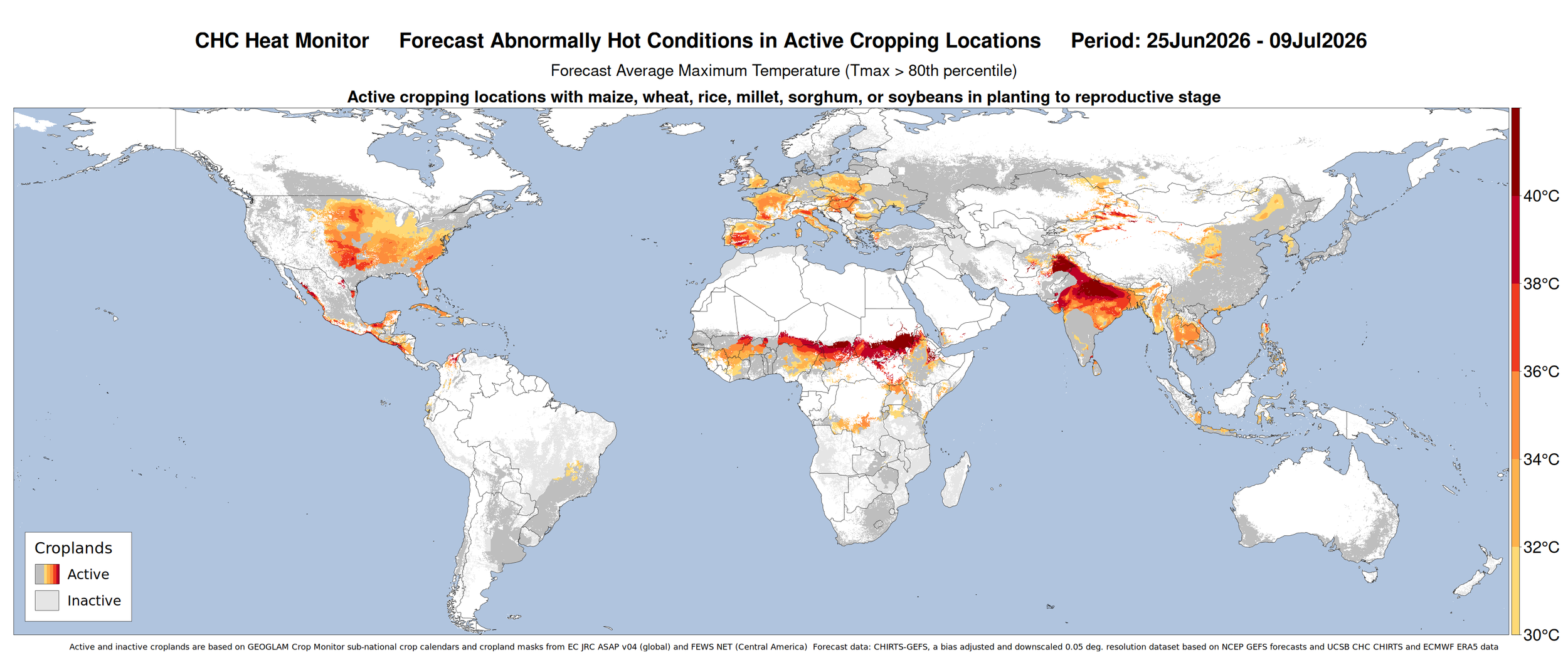
Figure 1: CHC AgriHeat Forecast for June 26 to July 10, 2026. Forecast 15-day average maximum temperatures are shown where these will be abnormally hot (Tmax > 80th percentile and > 30 C) and in active crop growing areas. Areas with forecasted below-average rainfall for this period are also identified using stippling. Based on 15-day CHIRTS-GEFS (Tmax) and CHIRPS-GEFS (precipitation) from June 26, 2026.
Source: UCSB Climate Hazards Cente
East Africa
Crop condition map synthesizing Maize 1 crop conditions as of June 28th. Crop conditions over the main growing areas are based on a combination of inputs including remotely sensed data, ground observations, field reports, national, and regional experts. Conditions that are other than favourable are labeled on the map with their driver.
Across northern East Africa, harvesting of Belg season maize is just beginning in Ethiopia, and concern remains in most areas that were impacted by a dry spell and below-average rainfall, except in the Former SSNPR region, as well as in northern areas impacted by movement restrictions. Planting and development of main season cereals continues in Sudan, South Sudan, Ethiopia (Meher season), and Yemen, with dry concerns in most areas as the rains have yet to fully establish, except in southeastern South Sudan where planting conditions remain favourable and in western Ethiopia where adequate soil moisture received during the antecedent Belg season allowed for some early season planting.
Across southern East Africa, harvesting of main season cereals finalized in unimodal regions in the centre and south of the United Republic of Tanzania under favourable conditions. Harvesting of main season cereals is underway in bimodal regions of Uganda, Rwanda, and Burundi, while crops continue to develop in Somalia, Kenya, northern Uganda, and bimodal regions of north and northeastern United Republic of Tanzania with dry concerns in most areas. Poor outcomes are expected in Somalia due to the delayed and below-average April to June Gu rains and higher than normal temperatures. Additionally, there is concern throughout most of Kenya, Uganda, Rwanda, and Burundi due to expanding rainfall deficits. Elsewhere, growing conditions remain favourable, including in central Kenya and bimodal regions of north and northeastern United Republic of Tanzania. Additionally, planting of second season maize is just beginning in northern Uganda with concern due to soil moisture deficits.
The March to May rainy season began early and prompted early land preparation and planting in many areas. However, total seasonal outcomes across East Africa were uneven, with extended dry spells occurring during key development stages, particularly in April. Generally dry conditions continued through June, worsening deficits in some areas. For the July to September period, drier than normal conditions are expected in most rainfall-receiving areas, particularly over Ethiopia, and temperatures are also expected to be warmer than normal over most parts of East Africa. Conversely, a shift to wetter than normal conditions is expected for the October to December period, in accordance with the expected positive IOD and El Niño event (See Climate Influences Pg. 3 and Regional Outlook Pg. 8).
Crop condition map synthesizing Maize 2 conditions as of June 28th. Crop conditions over the main growing areas are based on a combination of inputs including remotely sensed data, ground observations, field reports, national, and regional experts. Conditions that are other than favourable are labeled on the map with their driver.
Northern East Africa & Yemen
In Sudan, planting of main season millet and sorghum crops is just beginning with concern due to delayed and below-average rains that are expected to continue through September, associated with the current El Niño event, followed by a potential shift to wetter than normal conditions from October (See Climate influences Pg. 3 and Regional Outlook Pg. 8). Additionally, ongoing conflict continues to disrupt agricultural activities throughout the country. In South Sudan, planting and development of first season cereals continues for harvest from July, and conditions have been downgraded to watch in most areas due to emerging rainfall deficits. Cumulative rains for the March to May season were near average but characterized by uneven temporal distribution, including widespread early and above-average precipitation in March, followed by dry conditions through mid-May. In unimodal areas of the north and northeast, the early rains encouraged localized early planting; however, dry spells resulted in poor germination and crop wilting during late April and May. In bimodal areas of the southwest, dry spells negatively affected crop growth. Additionally, a continuation of below-average rains is expected across the country through September (See Regional Outlook Pg. 8). Conversely, planting conditions remain favourable in Kapoeta region located in the southeast. Protracted internal conflict continues to disrupt crop production, and ongoing supply chain disruptions related to the ongoing conflict in the Middle East continue to increase fuel prices and supply costs. In Ethiopia, harvesting of Belg season maize crops is just beginning, and most regions were impacted by a dry spell and below-average rainfall, except for the Former SNNRP region where conditions remain favourable. Additionally, movement restrictions negatively impacted cropping activities in Amhara and Tigray regions in the north. Planting of Meher season cereals is just beginning, and overall conditions are mixed due to expanding rainfall deficits. Good soil moisture conditions during the antecedent February to May Belg season continued to benefit some Kirempt rainfall-receiving regions in the west, including western Beneshangul Gumu, Gambela, and parts of Former SNNPR, which may have resulted in early planting. However, areas that planted with the off-season rains are likely to experience a shift to dry conditions in the coming months, which could lead to crop wilting. Elsewhere, the June to September Kirempt season has been characterized by a delayed onset and below-average rainfall amounts, resulting in moisture deficits and crop stress. Additionally, forecasts indicate dry conditions for the July to September period, particularly in the central-east, which is associated with the current El Niño event. Abnormally high temperatures in the coming weeks could exacerbate moisture loss in rainfall deficit areas (See Climate Influences Pg. 3 and Regional Outlook Pg. 8). During past years with similar El Niño conditions, Meher season maize and sorghum yields were below normal in Ethiopia, with the largest losses in eastern Amhara, Tigray, and northeastern Oromia. Yield losses in western Ethiopia were less severe. At the national level, yields were 2 percent below normal on average, with possible deficits exceeding 10 to 15 percent. In Yemen, sorghum crops are in the vegetative to reproductive stage, while spring wheat planting is just beginning. While good rains between March and April supported crop establishment and early development, recent dry spells and below-average rainfall could reduce production. Forecasts indicate a potential shift to below-average precipitation in parts of the country that could constrain crop development, and ongoing conflict in the Middle East continues to disrupt agricultural input access, particularly fuel and fertilizers.
Crop condition map synthesizing Sorghum 1 conditions as of June 28th. Crop conditions over the main growing areas are based on a combination of inputs including remotely sensed data, ground observations, field reports, national, and regional experts. Conditions that are other than favourable are labeled on the map with their driver.
Southern East Africa
In Somalia, Gu season maize and sorghum crops are in the vegetative to reproductive stage for harvest from July. Prolonged dry conditions, including failed October to November 2025 Deyr rains, followed by erratic and generally poor April to June 2026 Gu rains, as well as hotter-than-normal temperatures are expected to result in below-average yield outcomes across the country. In Kenya, long rains cereals are entering the vegetative to reproductive stage, and conditions have been downgraded to watch in most areas due to emerging rainfall deficits, except in the centre. The March to May long rains were above average, except in some central and coastal areas. However, heavy early-season rains resulted in limited field access, disrupted mechanized operations, and delayed planting in parts of the North and South Rift. Additionally, the temporal rainfall distribution was uneven, and most areas received below-average amounts in April and early May when the season typically peaks, followed by a continuation of below-average amounts in June. Crops have been negatively impacted by the dry spells, according to field reports from some North Rift areas. However, conditions along the coast are improving due to recent increased rainfall. In unimodal and major producing areas in the western half of the country, precipitation from June to September is expected to be below average due to the current El Niño event, raising the risk of reduced production levels (See regional Outlook Pg. 8). Furthermore, the ongoing conflict in the Middle East continues to disrupt fuel supply and increase transportation and food costs. In Uganda, harvesting of first season cereals is just beginning, and overall conditions have been downgraded to watch due to erratic timing and distribution of the March to May rains, followed by below-average precipitation received in June. An early onset of the March to May rains in February was followed by above-average precipitation through March and then a shift to a dry spell in early to mid-April, when rains typically peak. Insufficient rainfall in April resulted in delayed planting and crop wilting early in the season, and many farmers compensated with late-season planting and irrigation. While near-average rainfall in May benefitted early growth and crop recovery, a shift to below-average rainfall in June is raising concern for crop development across most areas. Additionally, planting of second season maize continues in the north, and conditions have been downgraded to watch due to soil moisture deficits for the start of the season. Forecasts indicate a likely continuation of dry conditions across the country for the July to September period (See Regional Outlook Pg. 8). In Rwanda, harvesting of Season B maize and sorghum crops is just beginning with ongoing concern due to continuing rainfall deficits. In Burundi, harvesting of Season B maize and rice crops is just beginning, and dry concerns remain despite recent rainfall improvements. While good rains were received in April and June, northern regions bordering Rwanda have remaining rainfall deficits, and earlier dry spells in the south may lead to a reduced harvest (See Regional Outlook Pg. 8). In unimodal regions of central and southern United Republic of Tanzania, harvesting of Msimu season crops finalized in June under favourable conditions due to generally adequate seasonal rainfall performance. In bimodal regions of the north and northeast, Masika season crops continue to develop for harvest from July, and overall conditions are favourable despite prior dry concerns.
For detailed description of the pie chart please see description box on the bottom of the page.
Regional Outlook: June to September 2026 Alert: Concerning recent dry conditions with forecast below-normal rains
Across many western and northern areas of East Africa, conditions were much drier and hotter than average during recent weeks, and these are forecast to continue. Below-average rainfall conditions observed during June are forecast to continue during upcoming weeks, based on a two week forecast from June 21st (Figure 1). Areas with moderate to severe rainfall deficits during this period include western and northwestern Kenya, Uganda, Rwanda, Burundi, northwestern Tanzania, South Sudan, southern Sudan, and southwestern, central and northern Ethiopia where rainfall totals are less than 30 to 60 percent of average. Longer-range weekly SubC and ECMWF forecasts, from June 24th, indicate this dryness will continue through July in many of these areas– in northwestern Kenya, northeastern Uganda, central and eastern South Sudan, Sudan, and much of Ethiopia. In Ethiopia, the exception is in the central-western region where average to above-average rainfall conditions are more likely.
Recent observed and forecast below-average rains are likely to lead to a slow establishment of the June to September rainy season in northern South Sudan, southern Sudan and Kiremt-rain receiving areas of northern, northeastern, central and eastern Ethiopia (see CHC Ethiopia Dekad 17 Monitoring Report). Higher rainfall zones in western Ethiopia are more resilient to suppressed rains, and are likely to maintain favorable soil moisture conditions and support agricultural activities.
In several western and northern areas where seasonal rains start in March, erratic and poor rains since April are likely to negatively affect crop performance. Cumulative seasonal rainfall totals since April remain below average, with severe rainfall deficits exceeding 200mm expected to persist in key crop growing areas of central and southwestern Ethiopia, western and North Rift Kenya (including Trans Nzoia, Bungoma, and Uasin Gishu counties), and unimodal areas of Uganda, where crops are in critical growth stages (Figure 1 top-middle). In Karamoja, northeastern Uganda where seasonal rains typically begin in April, rainfall has also been below average and interspersed by prolonged dry spells. Early estimates of April to June 2026 rainfall, using preliminary and forecast rainfall for June, indicate conditions that are close to the driest on record since 1981 in large parts of Uganda, and in portions of central, southwestern, and northwestern South Sudan, central-eastern Ethiopia, and high crop production zones in western Kenya (Trans Nzoia).
During July to September 2026, dry conditions are likely to continue. Based on the C3S and WMO multimodel ensemble forecasts and ICPAC July to September outlook (Figure 1 top-right) there are increased chances of below-average rains in western and northern areas. The ICPAC July to September outlook indicates greater than 60 to 80 percent chances of below-average rains in western Kenya, Uganda, South Sudan, Sudan, and western, northern, and central-eastern Ethiopia. Correspondingly, forecasts from NASA land surface models indicate below-average soil moisture, with the largest deficits forecast in western Kenya, northeastern Uganda, southeastern South Sudan, and southwestern and central-northern Ethiopia. The pessimistic outlook aligns with current El Niño conditions as well as the dry conditions observed in recent weeks.
Record high maximum temperatures during the past 30 days occurred in rainfall deficit areas of western Kenya and eastern and northern Uganda (Figure 1 bottom-left). Very high temperatures are forecast to continue during the next 30 days (Figure 1 bottom-right), with extreme heat forecast in southeastern Sudan, northeastern South Sudan, northern and southwestern Uganda, and central-northern Ethiopia. Very high temperatures are forecast in JAS 2026, with ECMWF and NMME models indicating high (> 70 percent) chances that temperatures will be above the 90th percentile. Abnormally high temperatures are likely to exacerbate moisture loss in rainfall deficit areas, posing critical risks to crops and rangeland resources.
Figure 1. Recent Anomaly Outlook, Seasonal Anomaly Outlook, Probabilistic Rainfall Outlook for July to September 2026, 30-day Temperature and 30-day Temperature Anomaly Outlook. The Top-left and Top-middle panels are CHC Early Estimates, which compare the June 1st to July 5th, 2026 (Top-left) and April 1st to June 30th (Top-middle) precipitation totals to the 1996–2025 CHIRPS averages for the same accumulation period. Top-right: July to September 2026 rainfall forecast from the IGAD Climate Prediction and Applications Centre (ICPAC). Bottom-left: Average daily maximum temperatures for May 20th to June 18th, 2026. Bottom-right: SubC multi-model 30-day temperature tercile probability forecast for June 24th to July 23rd, 2026.
Source: UCSB Climate Hazards Centre
During October to December (OND) 2026, there are moderate to high chances of above-normal rainfall in the region (Figure 2-left). One of the more confidently forecast regions is the Short Rains/Deyr rainfall season zone of eastern East Africa (central-eastern Kenya, southeastern Ethiopia, and southern Somalia), where there is a robust observed relationship between above-normal OND seasons and positive Indian Ocean Dipole (IOD) and El Niño conditions, which are indicated by most models.
The odds of strong positive IOD and El Niño conditions occurring in OND 2026 are very high– around 90 percent chances (NOAA CPC ENSO Outlook from June and Figure 2-left). OND 1982, 1991, 1997, 2015, 2019, and 2023 seasons stand out as the most similar years in the observed SST record, relative to the June 2026 NMME model ensemble mean OND 2026 SST forecasts for the Relative ONI (RONI) and the IOD index (Figure 2-right). 1997, 2019, and 2023 are notable for their very warm western Indian Ocean SST during strong positive IOD; 1982, 1991, 1997, and 2015 are identified from their very high RONI values, representing the strongest El Niño seasons.
With the OND 2026 rainfall outlook is the likelihood that a wet season will support increased crop planting and yields and improve pasture and water availability, which are needed following the below-average OND 2025 and Gu 2026 rainfall seasons in eastern areas. However, the forecast conditions driving the OND outlook raises concerns about elevated population risks from floods or waterborne disease, and damages to roads, low-lying or riverine farms and settlements, and crop losses from excessive soil moisture.
While the outcomes in OND 2026 will be unknown until the season is underway, among the identified most similar IOD and El Niño years (to the 2026 forecast) are examples to prepare for. There was extensive flooding in 1997 in Ethiopia and Kenya and 2023 in Somalia, less extensive but highly impactful 1997 and 2019 floods in Somalia and 2023 in Kenya, and localized flooding in 2015. The excessive rains of OND 2019 substantially raised Lake Victoria water levels– a factor in elevated post-2020 South Sudan flooding.
Conditions in 1997 sparked the worst flooding Ethiopia had seen in 40 years. Floods during OND 1997 —typically the dry Bega season— brought devastating consequences to both crop-producing highlands and lowland pastoralist communities. The unseasonal rains severely disrupted the vital Meher (main) harvesting season. Mature crops waiting to be reaped were rotted, washed away, or heavily downgraded in quality, slashing the Ethiopia national crop yield by over 25%. See Korecha (2026) for a comprehensive overview of Ethiopia's impacts. Kenya’s 1997/98 main season maize crop– which accounts for 80 percent of annual output– was also negatively impacted by torrential rains at harvest time in October-November, after an earlier dry spell had already reduced yields (GIEWS, February 1998).
Figure 2. October to December 2026: Forecasts for rainfall, El Niño, and Indian Ocean Dipole Left: NMME 3-month multimodel ensemble forecast tercile probability for October to December (OND) 2026 precipitation, based on June initial conditions and a 1991-2020 model baseline. From UCSB CHC MME. Right: The current ENSO/Relative ONI (RONI) and Indian Ocean Dipole (IOD) forecast for OND 2026, compared to historical observations (scatterplot), and historical rainfall tercile outcomes (filled colors) in eastern East Africa (EEA; Fig. 2-right box, 8.5N-4.5S, 38E-50E). The June NMME mean OND 2026 forecast value for RONI and IOD values is shown with a range of values within an 80% confidence interval (large and small red triangles, respectively), post forecast bias-correction using historical 1991–2025 forecasts. The most relevant (to this forecast) historical years are identified, based on these intervals for RONI and IOD (black outlines).
Source: UCSB Climate Hazards Center
West Africa
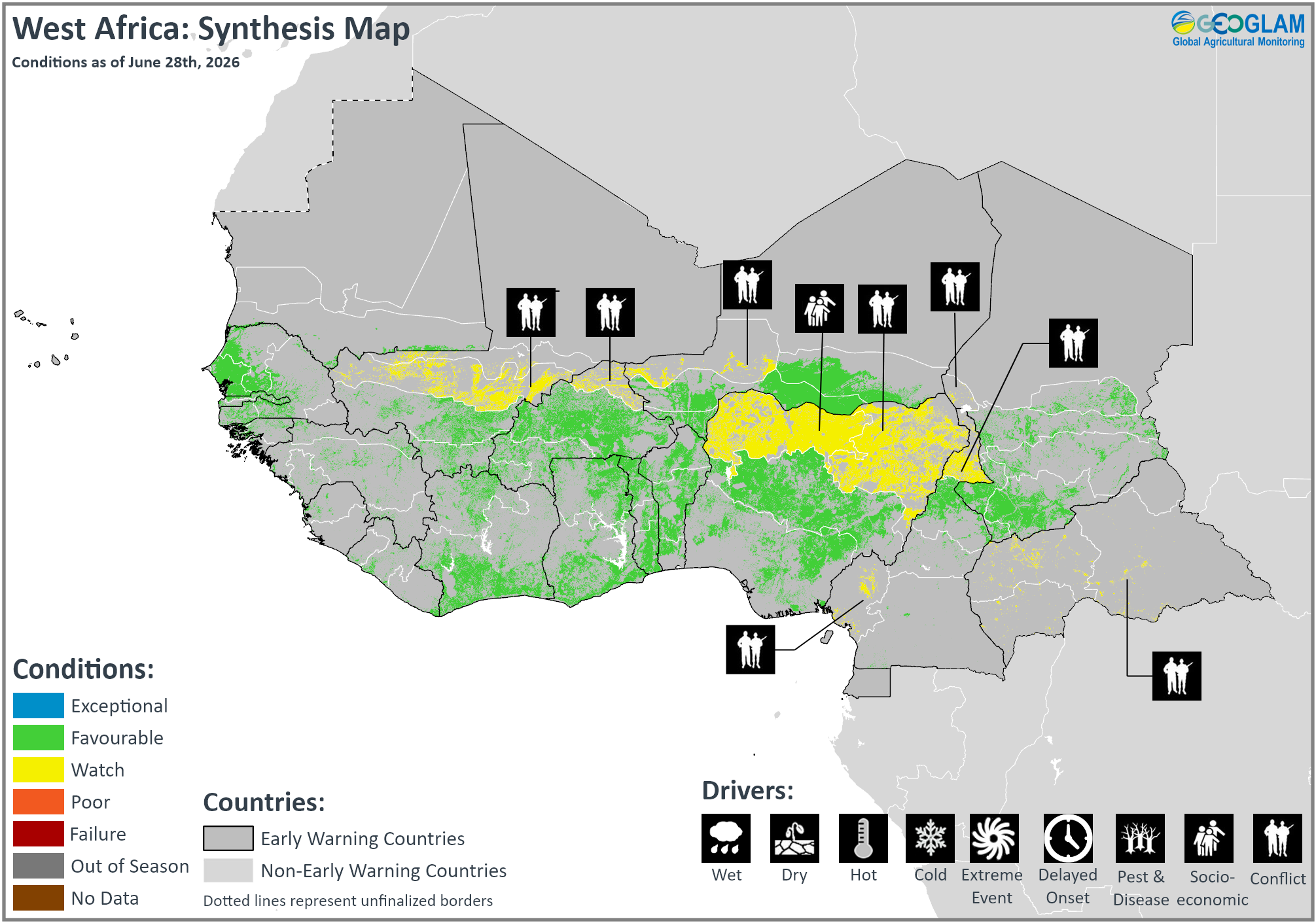
Crop condition map synthesizing crop conditions as of June 28th. Crop conditions over the main growing areas are based on a combination of inputs including remotely sensed data, ground observations, field reports, national, and regional experts. Crops that are in other than favourable conditions are labeled on the map with their driver.
In southern West Africa, planting and development of main season cereals are underway in all regions, including Guinea, Sierra Leone, Liberia, Côte d’Ivoire, Ghana, Togo, Benin, Nigeria, Cameroon, and the Central African Republic. Additionally, planting of second season rice is underway in the northern half of Nigeria. Along the Sahel, planting of main season cereals is underway in all regions, including in Guinea-Bissau, Senegal, Gambia, Mauritania, Mali, Burkina Faso, Niger, and Chad. Across West Africa, agro-climatic conditions remain generally favourable for ongoing crop development, though rainfall onset is delayed in some areas of the Sahel, including in central-eastern Nigeria and southeastern Chad. According to CHIRPS3.0 rainfall totals from March 1 to June 10, the southern part of the subregion, from southern Guinea to the Central African Republic, received up to 400 mm of rainfall, while coastal areas received up to 800 mm. Conversely, rainfall totals are up to 300 mm in the southern part of the Sahelian strip and less than 75 mm in the northern part. Forecasts indicate chances of high temperatures and mixed rainfall outcomes during the June to September rainy season. Additionally, conflict continues to adversely affect agricultural outcomes in central Mali, northern Burkina Faso, western Niger, the Lac region in Chad, northeastern Nigeria, northern and southwestern Cameroon, and the Central African Republic, and socio-economic challenges related to inter-communal conflict continue to impact northwestern Nigeria. In Nigeria, overall cultivation this season is expected to be below average due to ongoing insecurity, which has severely restricted land access, as well as the ongoing crisis in the Middle East, which has increased the costs of key inputs such as petroleum products and fertilizers.
Middle East & North Africa
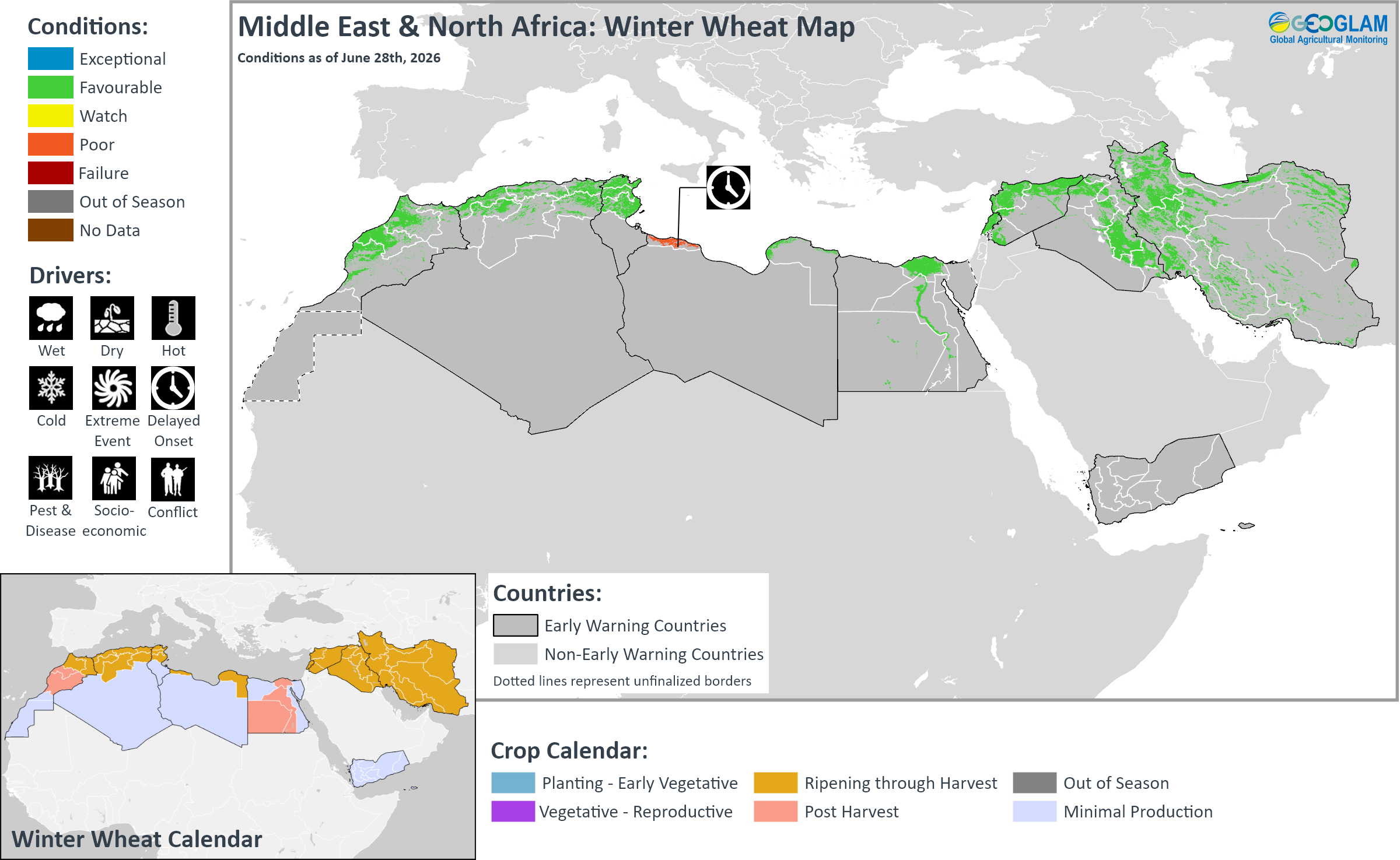
Crop condition map synthesizing Winter Wheat conditions as of June 28th. Crop conditions over the main growing areas are based on a combination of inputs including remotely sensed data, ground observations, field reports, national, and regional experts. Crops that are in other than favourable conditions are labeled on the map with their driver.
Across the Middle East and North Africa, winter wheat harvesting finalized in Egypt and is complete or nearing completion in Morocco, Algeria, Tunisia, Libya, Lebanon, Syria, Iraq, and Iran, with mostly favourable yield outcomes expected. A dry start to the season in October through mid-November 2025 was followed by rainfall improvement that benefitted cropping prospects in most areas. However, delayed rainfall onset at the beginning of the season is expected to result in yield declines in western Libya. In southern Iraq, production is expected to decline due to a government decision to limit the area of cultivation using surface water, though yield of irrigated cereals is expected to be near average. Additionally, planting and development of rice crops continues in Egypt, Iraq, and Iran under favourable conditions.
In Morocco, harvesting of winter cereals finalized in June with good prospects following four consecutive years of below-average production. The 2026 cereal harvest is expected to reach 9 million tonnes, including 4.4 million tonnes of soft wheat, 2.1 million tonnes of durum wheat, and 2.5 million tonnes of barley, according to the Ministry of Agriculture. The European Commission Joint Research Centre estimates a total wheat yield of 2.45 tons per hectare, representing a 37 percent increase compared to the five-year average. This year, increased mechanization benefitted crop yields and harvest operations, and new grain storage facilities have improved storage capacity. In Algeria, the European Commission Joint Research Centre estimates a total wheat yield of 1.76 tons per hectare, representing a 17 percent increase compared to the five-year average. In Tunisia, the European Commission Joint Research Centre projects the second-best harvest in the past decade, with a total wheat yield of 2.41 tons per hectare, representing a 15 percent increase compared to the five-year average.
In Syria, wheat prospects remain favourable despite recent localized flooding impacts. From mid-May, upstream rainfall, seasonal snowmelt, and large-scale dam water releases resulted in severe flooding of the Euphrates River, impacting Deir ez-Zor, Ar-Raqqa, and Aleppo governorates. An estimated 85 percent of irrigation systems were reported as nonfunctional in affected areas, and the floods destroyed standing wheat, barley, cotton, and vegetables prior to harvest. In Deir‑ez‑Zor, the floods impacted 7,210 hectares of agricultural land, representing 8.2 percent of the cultivated land. In Iran, wheat harvesting is expected to continue through July with favourable outcomes expected, except in a localized area in the centre of the country between Tehran and Esfahan. Dry conditions in October and November 2025 delayed planting activities but were followed by improved rainfall from December 2025, which replenished soil moisture and benefited crop development, particularly in the major producing governorates of Khuzestan, Fars, Golestan, Kordestan, and Khorasan. In April 2026, the government announced a minimum wheat procurement price in response to supply chain disruptions and rising production costs relating to the ongoing conflict in the Middle East. FAO estimates 2026 wheat production of 13.7 million tonnes, representing a 14.2 percent increase from 12 million tonnes in 2025. Additionally, rice growth continues in Gilan and Mazandaran provinces under favourable conditions.
Southern Africa
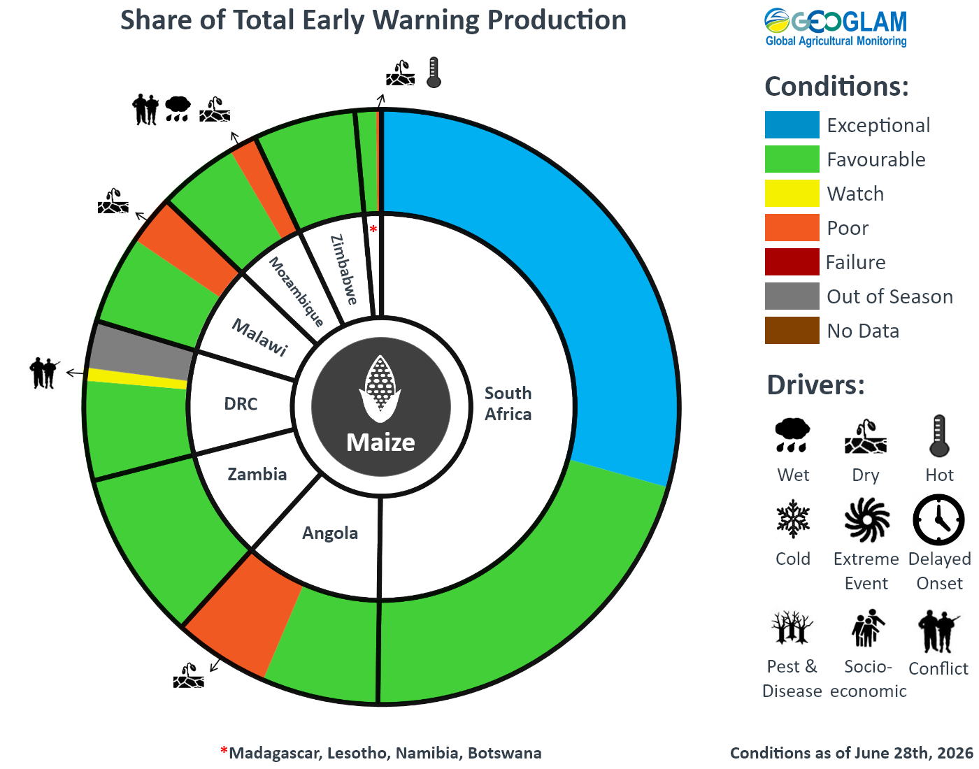
Crop condition map synthesizing maize end of season (EOS) conditions as of June 28th. Crop conditions over the main growing areas are based on a combination of inputs including remotely sensed data, ground observations, field reports, national, and regional experts. Crops that are in other than favourable conditions are labeled on the map with their driver.
Across Southern Africa, harvesting of main season cereals is now complete in all countries, including Angola, Namibia, Botswana, Zimbabwe, Zambia, Malawi, Mozambique, Madagascar, South Africa, Lesotho, and eSwatini. End of season conditions are generally favourable despite unevenly distributed rainfall, including periods of flooding and dry spells in several areas. Conversely, yield declines are expected in western Angola, which experienced dry conditions for much of the season; in southern Malawi, which experienced dry spells from mid-January to mid-February; in southern Mozambique, which experienced periods of heavy rains and flooding and a severe dry spell; and in southern Madagascar, which experienced poor seasonal rainfall outcomes and high temperatures. Additionally, ongoing conflict negatively impacted yield outcomes in northeastern Mozambique. Overall production for the subregion is expected to be above average, driven by a 10 percent above-average maize output in South Africa, a record harvest in Zambia, and a 2 percent production increase in Zimbabwe compared to the previous year, according to the European Commission Joint Research Centre.
Planting for the 2026/27 main season will begin in September. During past years with similar El Niño conditions, maize yields were below average in Zimbabwe and South Africa. Total production of maize and sorghum has been 10 to 15 percent below normal, with deficits over 40 percent possible.
In Malawi, generally conducive rainfall outcomes this season are expected to result in average production at the national level. However, dry spells during maize flowering from mid-January to mid-February resulted in moisture stress and reduced yields in parts of the south. Conversely, heavy rainfall from March 15 to 20 resulted in flash flooding and localized crop losses in central and southern areas. In Cabo Delgado province located in northeastern Mozambique, a combination of ongoing conflict, displacement, and market and livelihood disruptions is expected to result in a below-average harvest. In Gaza province located in the south, a combination of severe flooding in January and March and a dry spell in February resulted in a loss of 41 percent of planted crops and a below-average harvest. In Lesotho, harvesting outcomes are expected to be favourable, following an above-average planted area and a conducive rainy season. However, erratic heavy rainfall since late April resulted in waterlogging, particularly in the southern lowland districts of Mafeteng, Mohale’s Hoek, and Maseru. In affected areas, 30 to 50 percent of potato and bean crops, 20 to 30 percent of maize crops, and 10 percent of sorghum crops have been lost due to the recent heavy rains. Likely below-average production in the southern lowlands will be offset by above-average production in the surplus-producing areas of the foothills and northern lowlands.
In the Democratic Republic of the Congo, main season sorghum and maize and second season maize are at varying stages of development, and harvesting finalized in the southeast. Normal rainfall outcomes have generally supported agricultural activities during the first growing season. However, flooding was reported in parts of North Kivu, South Kivu, Maniema, Kasai, Lomami, Tshopo, Kinshasa, and Tanganyika provinces in April and May and resulted in localized land loss and livelihood impacts. Conversely, the country experienced a shift to below-average rainfall and high temperatures in June, though overall growing conditions remain favourable. Additionally, escalating conflict in eastern provinces since late January 2025 has resulted in widespread displacement and restricted field access, which have severely disrupted agricultural activities. Furthermore, ongoing insecurity in the Middle East continues to disrupt the supply of petroleum products, increasing fuel prices.
Planting of winter wheat continues in Zambia, Zimbabwe, South Africa, and Lesotho under favourable conditions. In Zimbabwe, winter wheat planting reached 126,394 hectares, representing 101 percent of the national target of 125,000 hectares, according to the Ministry of Agriculture. In South Africa, conditions are favourable for both dryland and irrigated wheat production following wet conditions during late summer and autumn, which resulted in high soil moisture and abundant irrigation water. In the Western Cape, widespread above-normal rainfall received during April and May benefitted crop emergence.
For detailed description of the pie chart please see description box on the bottom of the page.
Central & South Asia
Crop condition map synthesizing wheat conditions as of June 28th. Crop conditions over the main growing areas are based on a combination of inputs including remotely sensed data, ground observations, field reports, national, and regional experts. Crops that are in other than favourable conditions are labeled on the map with their driver.
In Central & South Asia, wheat harvesting is complete or nearing completion in Pakistan (Rabi season) and Afghanistan, while winter wheat harvesting is just beginning in southern Kazakhstan, Kyrgyzstan, Tajikistan, Uzbekistan, and Turkmenistan. Additionally, spring wheat is in the vegetative to reproductive stage across Kazakhstan, Kyrgyzstan, Tajikistan, and Mongolia. Agro-climatic conditions remain favourable across all regions. During past years with similar El Niño conditions, wheat yields increased across much of Central Asia.
In Uzbekistan, FAO estimates the 2026 wheat harvest at 14.7 million tonnes, unchanged from the 2025 production. In Kazakhstan, FAO estimates the 2026 wheat harvest at 14 million tonnes, representing a 22.2 percent decline from 18 million tonnes produced in 2025 due to a reduction in the planted area of spring wheat in favour of more profitable crops. In Afghanistan, the 2025/26 wheat cropping season began with delayed and below-average precipitation from October to mid-December 2025, high temperatures, and low snow accumulation. However, rainfall improved from mid-December 2025, and well-distributed rains from January through May 2026 supported crop establishment and recovery in major agricultural areas, despite periods of intense rains and subsequent flooding in some regions. The cumulative October 2025 to May 2026 rains were below average in most areas, with localized areas receiving average to slightly above-average amounts. Snow water volumes (SWV) continue to be at record minimum levels in the northeastern Panj, Kokcha_Ab-i-Rustaq, and Khanabad basins and are at 50 percent of the normal volume in the Kunduz basin. Harvesting activities are complete or nearing completion and may extend through mid-August across the highest elevations of the northeast and central highlands. Despite below-average cumulative precipitation and snowpack levels, the overall 2025/26 wheat yield and production is expected to be near normal. Planting of second season crops (mainly maize and rice) is just beginning and will continue following the wheat harvest. Surface water is generally sufficient to support second season crop planting in most river basins. Groundwater will be increasingly utilized as the season progresses, particularly in downstream areas during the latter part of the growing season when surface water supplies typically decline. April and May precipitation improved groundwater conditions in some localized areas, but levels remain below average in most basins. Groundwater resources continue to face significant pressure due to extensive agricultural use, particularly in areas where previously barren land has recently been converted for cultivation and lacks access to established canal networks for irrigation. El Niño events are typically associated with above-average precipitation during October through April, which would increase short-term groundwater recharge. In Pakistan, harvesting of Rabi wheat finalized in June under favourable conditions, and FAO estimates 2026 wheat production of 29.3 million tonnes, representing a slight increase from the previous year. Additionally, planting of Kharif season rice and main season maize and millet is underway, and start of season conditions are favourable. Crop establishment and early development are progressing normally, supported by adequate irrigation water supplies and the onset of the summer monsoon. Surface water from the Indus irrigation system continues to support agricultural activities across most canal-irrigated areas. In areas with insufficient canal water, farmers rely on groundwater to supplement crop water requirements.
Southeast Asia
Crop condition map synthesizing rice conditions as of June 28th. Crop conditions over the main growing areas are based on a combination of inputs including remotely sensed data, ground observations, field reports, national, and regional experts. Crops that are in other than favourable conditions are labeled on the map with their driver.
In southern Southeast Asia, harvesting of wet-season rice is expected to finalize in June with near-normal production outcomes. Harvesting of wet-season maize is nearing completion with generally favourable yields expected due to sufficient irrigation water and sunlight. Additionally, planting of dry-season rice is progressing despite some delays, and overall crop conditions remain favourable due to stable weather outcomes and adequate irrigation water supply. Dry-season maize is in the peak seeding stage under favourable growing conditions due to sufficient irrigation water.
In northern Southeast Asia, harvesting of dry-season maize is complete, and production is expected to decrease slightly due to a decline in both sown area and yield. Additionally, the planted area of wet-season rice is expected to be normal to slightly below normal. Wet-season rice is in the seeding to tillering stage, and early growing conditions are generally favourable. Wet-season maize is mainly in the seeding to vegetative stage, and growing conditions are generally favourable due to adequate rainfall. However, a potential rainfall shortage this season could negatively impact wet-season crop development, particularly in Thailand. Additionally, higher input costs are negatively impacting wet-season planting activities in Thailand and southern Viet Nam.
Elsewhere in Southeast Asia, including Sri Lanka, Nepal, Bangladesh, and the Democratic People’s Republic of Korea, overall conditions are favourable, and crops in the Democratic People’s Republic of Korea have recovered from early-season drought.
During past years with similar El Niño conditions, rice production decreased in Cambodia, Sri Lanka, Indonesia, and Thailand due to a combination of decreased yields and planted areas (See GEOGLAM Special Report: El Niño 2026-2027: Anticipated Climate and Agricultural Yield Impacts).
In Indonesia, the wet-season rice harvest is expected to finalize in June, with the total harvested area reaching 6.3 million hectares, a slight increase over last year. However, wet-season rice yield is expected to be slightly lower than the previous year due to reduced rainfall during the growing period. June is also the final month of wet-season maize harvesting, with a total harvested area of 1.46 million hectares, which is 2.4 percent lower than the last wet season. The yield is generally favourable, supported by sufficient irrigation water and sunlight. Additionally, June marks the third month of dry-season rice planting, with the total planted area of 2.9 million hectares. However, planting activity remains relatively low as many farmers are still preparing land following the wet-season harvest. Dry-season maize sowing is also in its third month, with a total sown area of 0.7 million hectares, which is slightly higher than last year. Growing conditions are generally favourable due to sufficient irrigation water. In Malaysia, most remaining wet-season maize fields are currently at the maturity stage, and harvesting continues under favourable conditions. Planting of dry-season rice has reached approximately 78 percent of the target area, and early harvesting has reached 20 percent of the planted area. Overall, dry-season rice conditions remain favourable, supported by stable weather conditions and adequate irrigation water supply. Dry-season maize is in the seeding stage under favourable weather conditions. In Brunei, planting of dry-season rice is now complete. About 10 percent of the planted area will soon be ready for harvest, while the remaining area is mostly in the latter half of the tillering stage and panicle forming stage under favourable weather conditions. High solar radiation rates are expected to benefit yield outcomes over the next few months.
Crop condition map synthesizing maize conditions as of June 28th. Crop conditions over the main growing areas are based on a combination of inputs including remotely sensed data, ground observations, field reports, national, and regional experts. Conditions that are other than favourable are labeled on the map with their driver.
In the Philippines, wet-season rice planted from April to May is in the tillering to young panicle forming stage with an expansion in the planted area. Overall wet-season rice growing conditions are favourable, and near to above-normal rainfall is expected in the coming months. Wet-season maize planted from April to May is in its vegetative and tasselling stages, and the planted area increased across Luzon provinces. Wet-season maize conditions remain favourable due to conducive weather outcomes and sufficient water supply from irrigation facilities. A 7.8 earthquake impacted the south of the country on June 8, resulting in aftershocks and damaged infrastructure, though the earthquake did not significantly impact wet-season rice or maize prospects. In Thailand, planted area of wet-season rice is expected to decline due to lower rice prices and rising production costs, particularly for fertilizers, pesticides, and fuel. Wet-season rice is currently in the sowing and early tillering stages, and yield is expected to decrease as a result of drought conditions and reduced fertilizer application. Consequently, total rice production is projected to be lower than last year. The planted area of wet-season maize is expected to decline from last year. In addition, rising fertilizer and fuel costs have encouraged some farmers to shift to alternative crops such as cassava or rubber trees. Wet-season maize is currently in the seeding stage, and yield is also projected to decrease due to dry conditions. Consequently, total maize production is expected to be lower than last year. In northern Viet Nam, dry-season (winter-spring) rice is currently being harvested with an area of 0.36 million hectares, and harvesting activities are accelerating with
the onset of the rainy season. Yield prospects are favourable, supported by conducive weather conditions and adequate irrigation water availability. Throughout the country, harvesting of the dry-season maize crop is nearing completion. Seasonal weather conditions were generally favourable, with adequate rainfall and sufficient soil moisture supporting normal crop development throughout the season. Consequently, the yield is expected to be slightly above the previous year. In the south, wet-season (summer-autumn) rice is in the sowing and tillering stages. The planted area reached 0.83 million hectares, and planting progress is slower than in the previous year due to delays in harvesting of the antecedent winter-spring crop, prolonged hot weather in some areas, and higher fertilizer and pesticide prices. In Laos, the dry season maize harvest is nearing completion with a harvested area of over 12 thousand hectares, equivalent to 80 percent of the national planted area. The average yield is estimated at 4.93 tons per hectare, slightly below last year’s level, with total production projected at around 61 thousand tons. Favourable weather and adequate irrigation from March to May supported crop growth this season despite localized drought stress in some southern provinces. Additionally, wet-season rice has entered the ploughing and field preparation stage, and early planting has begun, progressing smoothly across the northern and central provinces. The national planting plan for lowland rice this year is around 833 thousand hectares, reflecting a modest increase from the previous year. Production is expected to exceed 3.3 million tons, supported by initial rainfall in late May and early June. Wet-season maize is in the land preparation stage, and early sowing has begun in northern and central provinces. Initial rainfall in late May and early June has supported germination and early growth. In Myanmar, harvesting of dry-season rice is nearing completion under favourable conditions, with over 930 thousand hectares harvested. Production has reached 5.2 million tons of paddy with a yield of 5.5 tons per hectare, which is similar to last year. Additionally, the national planting plan for wet-season rice this year is set at 6.04 million hectares. Planting of wet-season rice began in June, reaching 157 thousand hectares in rainfed areas, which accounts for 2.6 percent of the national plan. Planting of wet-season maize began much earlier than last year in major producing regions due to the early monsoon, widespread rainfall, and good sunlight. The crop is currently in its seeding to leaf development stage, with conducive weather providing favourable growing conditions. In Cambodia, the planted area of wet-season rice reached 58 percent of the national plan of 2.94 million hectares. Crops are in the tillering stage under favourable conditions with adequate sunlight. Wet-season maize is in the vegetative stage, and the sown area reached 48 percent of the national plan of 159 thousand hectares. Growing conditions are favourable due to adequate rainfall.
In Sri Lanka, Yala season rice (40 percent of annual rice output) and Yala season maize (10 percent of annual maize output) are in the vegetative to reproductive stage under favourable conditions for harvest from August. In Nepal, harvesting of winter wheat and spring season rice finalized in June under favourable conditions. Additionally, planting and development of main season crops continue under favourable conditions. In Bangladesh, harvesting of summer (Kharif) season maize (15 percent of annual maize production) is just beginning while Aus season rice (10 percent of annual rice production) is in the vegetative to reproductive stage. Additionally, planting of sorghum and Aman season rice (35 percent of annual rice production) continues, and overall cropping conditions remain favourable. In the Democratic People’s Republic of Korea, maize crops are in the vegetative to reproductive stage while rice planting is nearing completion. Overall conditions are favourable with above-average biomass across all provinces as crops recovered from early-season drought. Wheat and barley harvesting finalized in June, and above-average crop biomass is expected to result in favourable yield outcomes that may compensate for the 8 percent decline in planted area compared to 2025.
For detailed description of the pie chart please see description box on the bottom of the page.
Central America & Caribbean
Crop condition map synthesizing Maize 1 (Primera season) conditions as of June 28th. Crop conditions over the main growing areas are based on a combination of inputs including remotely sensed data, ground observations, field reports, national, and regional experts. Conditions that are other than favourable are labeled on the map with their driver.
In Central America, planting of Primera season maize and bean crops is underway across Guatemala, El Salvador, Honduras, and Nicaragua, and there is ongoing concern for the start of the season across all regions due to erratic rainfall and high temperatures, which resulted in delayed planting and localized losses. Persistent below-average rainfall since late April has resulted in severe deficits in parts of Guatemala, Honduras, Nicaragua, and Haiti. While some areas recorded near-average rains, the total cumulative rainfall was received over a few days, and overall distribution is not in accordance with crop needs. Irrigation is being used to supplement in areas with systems in place, but capacity is diminishing due to the erratic rains and high temperatures. Dry and hot conditions are expected to continue through the July to September season and through the remainder of 2026, likely impacting the start of the Segunda season (See Regional Outlook Pg. 19). Furthermore, because June typically requires higher fertilizer application, high input costs are expected to mostly affect smallholder farmers, threatening yields for the upcoming Primera harvest. Global fuel price increases are particularly affecting El Salvador and Honduras, which show the highest year-on-year increase in the subregion, leaving smallholder farmers especially vulnerable.
In Haiti, harvesting of Printemps season maize and bean crops and main season rice crops is just beginning with concern due to reduced rains over the last two months. Residual moisture from rainfall received in March and April as well as the use of irrigation supported crops earlier in the season. However, rainfall declined across most of the country in May, and temperatures were above average, resulting in increased evapotranspiration rates, particularly in Gonaïves, Hinche, Fort-Liberté, and Port-au-Princ, as well as reduced irrigation capacity for crops. Vegetation health has declined in many affected areas, particularly in the Sud-Est and Ouest. Furthermore, protracted insecurity continues to constrain the agricultural sector. In Cuba, harvesting of second season rice (1/3 of annual rice production) finalized in June, while planting of main season rice and maize is underway. Despite generally favourable agro-climatic conditions, fuel and diesel shortages since January disrupted planting operations at the beginning of the season and limited harvesting activities, curtailing production prospects. The situation deteriorated sharply after additional sanctions imposed in May compounded the crisis. Fuel shortages have particularly affected food production, with output reportedly down as much as 60 percent.
For detailed description of the pie chart please see description box on Pg. 20.
Regional Alert: Below-average rainfall is forecast to continue during upcoming weeks and through 2026
Persistent below-average rainfall, which occurred in central areas of the region and in Haiti in recent weeks, have led to severe rainfall deficits since late April in Honduras, Nicaragua, Haiti, and parts of Guatemala.
During recent weeks, from May 21st to June 20th, conditions were much drier than normal in Haiti, central Honduras, and western and southern Nicaragua, with rainfall totals that were below 60 percent of average (Figure 1 top-left). Most of the central parts of the region experienced suppressed rainfall. Rainfall totals for May 21st to June 20th were above average in western Honduras and western El Salvador. Pacific Coast areas and central Guatemala received ample rainfall during early June, but drier-than-average conditions have since returned and are forecast to continue.
The regional rainfall deficits will worsen during the next two weeks, with a likely expansion in the locations undergoing abnormally dry conditions. A forecast-based outlook for April 1st to July 5th rainfall totals illustrates below-average conditions across most of Central America and Haiti (Figure 1 top-middle), with potential for extreme rainfall deficits in western Nicaragua, southern and central-northern Honduras, and portions of southern Guatemala. A widespread pattern of suppressed rainfall is indicated by the next 15-day unbiased GEFS forecast for June 25th to July 9th, signifying that the rainfall conditions will likely worsen by mid-July (Figure 1 top-right). This is consistent with the high chances of ongoing below-normal rainfall during July to September and the remainder of 2026 (Figure 1 bottom).
Crops impacted by ongoing moisture stress will be exposed to hotter and drier-than-average conditions in upcoming weeks. During the next two weeks, abnormally hot conditions are forecast throughout the Pacific coast and central parts of Central America and in Haiti, based on a bias-corrected next 15-day Tmax forecast for June 25th to July 9th. Much hotter-than-normal temperatures will very likely continue during the coming months and the Segunda 2026 growing season.
Figure 1. Recent rainfall anomaly, a seasonal rainfall outlook, and 15-day and 3-monthly rainfall forecasts spanning late June to December 2026. Top: CHC Early Estimates, which show rainfall estimated for May 21, 2026 to June 20th, 2026 (Left) and a forecast-based outlook for April 1 to July 5, 2026 (Middle). These show differences from the 1996-2025 average, for each time period, using CHIRPS3 preliminary data for June 1 to 20, 2026. The outlook includes a 15-day bias-adjusted NCEP GEFS forecast (CHIRPS3-GEFS) from June 21, 2026. CHIRPS3-GEFS forecast for next 15-day rainfall anomaly, for June 25 to July 9, 2026 (Right). Bottom: Probabilistic forecasts for July to September 2026 (Left) and October to December 2026 (Right) rainfall terciles. Based on June initial conditions, ECMWF SEAS5 and 6 NMME models (NMME only for OND 2026), and a 1991-2020 baseline of model hindcasts. NMME data is from the IRI Data Library; ECMWF data is from Copernicus. From CHC MME.
Source: UCSB Climate Hazards Center
Pie Chart Description: Each slice represents a country’s share of total regional production. The proportion within each national slice is colored according to the crop conditions within a specific growing area; grey indicates that the respective area is out of season. Sections within each slide are weighted by the sub-national production statistics (5-year average) of the respective country. The section within each national slice also accounts for multiple cropping seasons (i.e. spring and winter wheat) and are a result of combining totals from multiple seasons to represent the total yearly national production. When conditions are other than favourable icons are added that provide information on the key climatic drivers affecting conditions.
Information on crop conditions in the main production and export countries can be found in the Crop Monitor for AMIS, published July 2nd, 2026.
Sources and Disclaimers: The Crop Monitor assessment is conducted by GEOGLAM with inputs from the following partners FEWS NET, JRC, WFP, ARC, AFSIS, MESA, ICPAC, FAO GIEWS, Applied Geosolutions and UMD. The findings and conclusions in this joint multi-agency report are consensual statements from the GEOGLAM experts, and do not necessarily reflect those of the individual agencies represented by these experts.